
The Cerrado of Jaraguá
Jaraguá lies in the Cerrado biome, according to IBGE. The vegetation is made of small, twisted trees, with gallery forests along the rivers and an ipê bloom that paints the foot of the Serra in August and September.
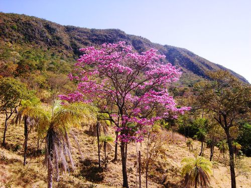
What the Cerrado is
The Cerrado is the biome of central Brazil, with a tropical savanna landscape and two well-marked seasons. In Jaraguá the dry season runs from May to September and the rainy season from October to April, with average annual rainfall of about 1,700 mm and temperatures from 17 °C to 33 °C. See the weather page.
The vegetation
- Cerrado: small, twisted trees dominate, with thick, wrinkled bark and large, brittle leaves.
- Typical fruits mentioned by Semad on the cerrado trails: pequi tree, cajuzinho-do-campo and mangaba tree.
- Gallery forests: strips of humid forest along the park's watercourses, where giant ferns contrast with the cerrado.
- Ipês: yellow and purple ipê trees bloom at the foot of the Serra between August and September, at the peak of the dry season, and are among the most photographed sights in town.
Terrain and waters
The municipality's territory is 55% flat, 35% rolling and 10% mountainous. The Serra de Jaraguá lies between the Rio das Almas and the Rio Pari, and the waters of the Rio das Almas cut through the Serra. Fish can be seen in the park's pools, according to Semad. The Rio das Almas rises in Pirenópolis. See geography and swimming in rivers.
Wildlife
Semad says the park receives wildlife watchers but does not publish a species list on the page consulted. The portal will not list animals without a source; if you are a researcher or observer, contact the park administration, at +55 62 3201-5295, about monitoring and permits.
How to visit without causing damage
- Stay on the trails and roads; shortcuts increase erosion.
- Do not pick flowers, fruit, plants or rocks. The park is a conservation unit.
- Make no fires. In the dry season, the vegetation burns easily.
- Take your trash away, including organic waste.
- Record with photos, not with collecting. See where to take photos.
Keep exploring
Sources: IBGE (predominant biome: Cerrado); Semad/Parques de Goiás (gallery forests, cerrado fruits, rivers and wildlife); the portal's geography page (terrain, climate, ipês). Consulted in October 2026.
Updated on October 19, 2026